Mapping Our Past to Plan the Future
Preserving and expanding the map collection at the University Library.
Give to the Map Collection
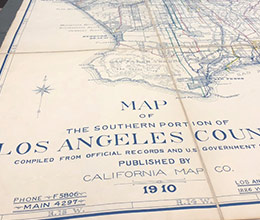
Ever wonder what CSUN looked like covered in orange, lemon and avocado groves before it was one of the country’s largest universities? Head over to the University Library Map Collection to find out. With approximately 400,000 historical and government maps, aerial photographs, atlases and geospatial data, the Map Collection is a treasure trove of information for students, faculty, staff and the community. The holdings span the globe, but emphasizes Western Americana and in particular, California, Los Angeles County and the San Fernando Valley.
Ever wonder what CSUN looked like covered in orange, lemon and avocado groves before it was one of the country’s largest universities? Head over to the University Library Map Collection to find out.
Researchers have access to historical road and tourist maps, planning and zoning maps, topographic maps, geologic and bathymetric maps, WWII maps from the Army Map Service and maps from other federal agencies like the United States Geological Survey, the Bureau of Land Management and the U.S. National Park Service. Core collections include historical street maps of the San Fernando Valley, the Thomas Guide City Street Atlas Collection, transportation maps and historical automobile road maps. Staff provide researchers subject expertise in cartographic resources, general and complex reference services, GIS research and technical support and map cataloging.
You gift expands the items in the collection, ensuring the Map Collection remains a vital center of research for the CSUN community and throughout the region.